A note to the designers of Blogger. You need to do something about accidental deletions. All I know is it has something to do with the CTRL key. A misplaced left pinky. or heel of the hand, and poof! 25 photos and text disappear.
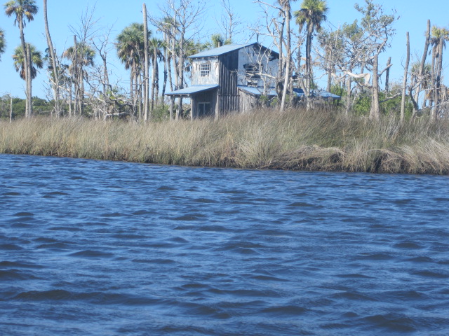
So back to the beginning. The view at breakfast.
Frontage and sideage. Out to the deck for a better view.
Off to the Chassahowitzka River, 11.5 miles away. Parking lot already over half full at 8:30. Kayaks on the grass at the ramp. A patient tour guide, making sure each person was comfortable, foot pegs properly adjusted, steadying each kayak as the person entered, pushing them into the River. I said hi to the guide, Tracy. If you ever want to take a tour on the Nature Coast, contact
Nature Coast Kayak Tours
The parking fee at the Chassahowitzka has gone up, again. Now $5. That delayed me as I had to go back to the car for more money. I was in the River at 8:54. With a manatee.
One I recognized, by a small circular scar. I've seen her before, in the spring downstream of the launch. I say "she" because I've seen her with a calf. I've also seen that she has a lot of scars criss crossing her back, in addition to the identifying circle. I wonder if any of them are new.
Vultures lined both banks of the Chassahowitzka, all the way to the island. I usually don't take vulture pictures, but I liked how one looks like its shading the other.
I stopped at the spring, left side, before reaching Baird's Creek, to check for manatees. None present. Or if there, did not surface.
Two belted kingfishers in one shot. That's a record for me.
Hey! I'm talking to you!
Another in the continuing series, Birds on Blue Goose Sign. Blue heron, here
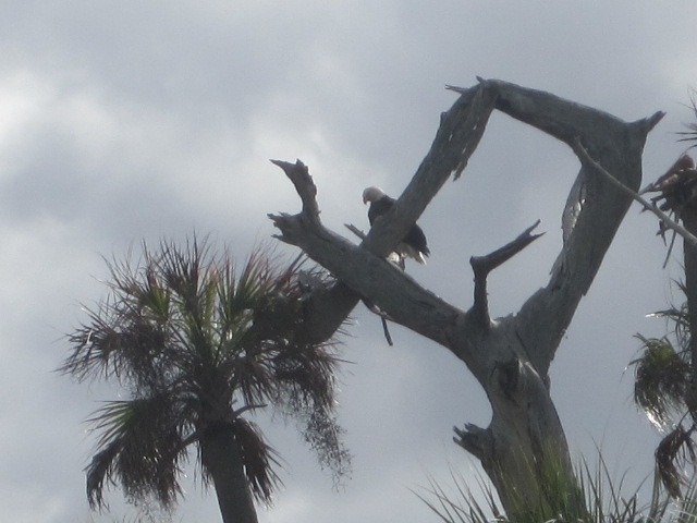
My paddling plan was to head down the Chass to Crawford Creek. Hopefully, seeing bald eagles and dolphin's.
Got the eagle. Into the salt marsh, trying for a closer look.
Not much better. But, on the way out,
A dolphin. Nice when a plan works out. This is where I was in the Tale when I lost it. And it will be where I stop for the evening. Lots more to come.
Good Sunday morning. I'll post a few more photos before leaving. Crossed the Chass to see these wood storks and more just upstream of Crawford Creek.
That's all for now. 9:25 am, I need to pack, and lock the door. But leave the car in the driveway and launch from the dock. With the owners' permission. Warm and windy forecast. I plan to paddle part of the old Citrus County Paddling Trail, which has been incorporated into the Florida Circumnavigational Paddling Trail.
Plan to paddle from here to Mason Creek.
http://www.dep.state.fl.us/gwt/paddling/Segments/Segment7/PDF/Seg7Map2.pdf "Here" being the inlet east of Battle Creek. I did this once before, from MacRae's. Got very confused south of Mason Creek. I have sine launched from Mason Creek, so I'll have a landmark. I also have an idea for a Christmas gift. A waterproof GPS, that can input latitude and longitude. My simple unit is good for street directions only.
See you tonight, or I may post a pic or two from the deck when I return.
I'm back, 7:33 now, just lost all I've posted since 6:35. At least I did not lose the older stuff. I was trying to type A. I suppose I hit the CTRL key, and that erased everything. With all due respect to computer nerds, it seems like an obvious design flaw to have the self destruct key so close to a key used with frequency. What happened to a "Are you sure you want to delte this?" warning. Here we go again.
Not all the woodstorks took flight. That's the opening photo. Those high up remained. The fliers must have liked what they was, because when I paddled across the River, looking for eagles in the dead palms, a favorite perch, the storks were there, too.
Paddled back across the Chassahowitzka, and began to paddle up Crawford Creek. Would I add alligators, deer, otters to the critter count? No. Not here, or for the rest of the day.
The hawk landed, and made a lot of noise. I had not had a photo op in 30 minutes, battling wind and current on Crawford Creek. I aimed the camera, the kayak drifted, a gap in the palms, "oh, an eagle, too"
I arrived at the spot where there are some interesting house on the Creek. More people than usual. Holiday weekend. And a November holiday would be a good to spend at these off the grid sites. No AC. THey are just downstream of where Blue Run enters Crawford Creek. I continued up Creek.
Two juvenile herons, blue and yellow crowned night.
See the fast moving water above? Coming out of Beetejay Spring. The Creek gets very narrow, and shallow, here. I've paddled to the Spring, but figured, in late November, it would be too shallow. Not to mention, I faced an into the wind paddle back on the Chas. So I turned around. 12:05.
Time for scenic photos. And lunch. A sandwich while standing in the creek. Sinking down a few inches in the soft bottom. No limestone here.
Back to where the Tale crashed. An adult blackcrowned night heron.
Some sort of jay?
I don't think I've seen so many wood storks in flight. This is just a small sample.
Back on the big river, the Chas, 1:24 PM. Time to paddle into the wind.
A good day for eagles.
Cormorants
Anhinga. The wind die down a bit, but I still took a short cut back. A short cut that involes taking an airboat route. One went by. The same one that had turned his engine off on narrow Crawford Creek. Appreciate that. But don't understand why anyone would want to use something so loud you have to where ear plugs.
Traffic wasn't bad on the Chass, but to avoid what there was, I went on the shallow, and scenic side of the island.
Fish dinner.
Can't see what the wood storks are eating.
Getting closer to the launch site, more people on the River. Including a group exiting the spring that manatees use. "Any other mammals?" "The baby is there" Must be locals, that's a big baby.
Maybe mon was away at the head spring in the morning as its time for Jr. to fend for his/herself. Got some good photos holding the camera underwater.
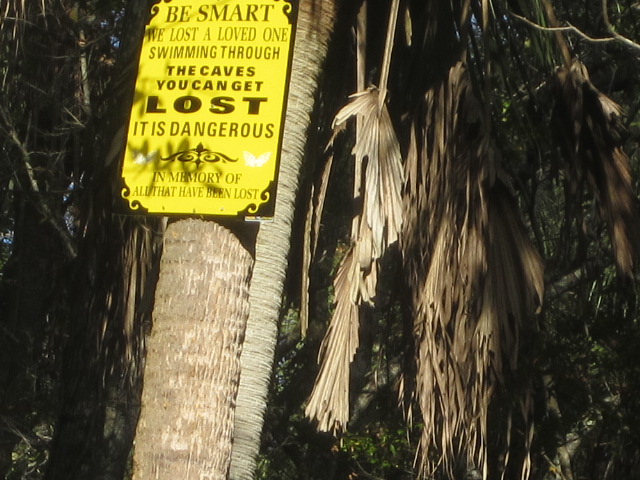
Back to the launch site, and past it to the small, interconnected springs that are one onf the sources of the Chas.
This sign is new. A search "Chassahowitzka caves death" Reveals 2 fatalities. One in 2006, one in April of 2011. I've swum through the caves. Maybe 20 lbs ago.
It had been awhile since I've even snorkeled the area. Just three people were in the springs, so I got out of the kayak and in the water.
I just poked my head in the holes to see the blueills and snapper.
The springs are tiny. Chassahowitzka Spring, on the other hand, is huge. But, no swimming, as it is in the middle of the boat channel. So once again, I held the camera underwater as I sat in the kayak.
Landed at 3:50 loaded the kayak, then drove south about 5 miles to the Suncoast Trail.
Trail fee? What's this, Wisconsin? Which has had trail fees for years. This is assessed by Hernando County.
I paid it. Figured I broke even, as the machine at Rogers Park only took 2 bucks on my debit card, Friday. The overnight rate, as the achine is not set for standard time.
Unlike most Florida paved bike trails, this is not on an old railroad right of way, but was built when a toll road was built. The cynic in me says they built the trail to have pavement for future road widening, but that would have to be a preety wide tollway.
A rolling ride, for Florida, but I think the escarpment above is from the road building process.
I rode about 5 miles. Short, but it was nice to be on the road bike again. It had a wobbly front wheel issue, which I figured out how to fix. One drawback about the parking lot. To go north, you need to drive a mile south before making a U-turn. Sheesh, for 3 bucks, I want a traffic light at the entrance.
Looking for a place to eat in Homosassa, I came across a local favorite "The Freezer" So named as you eat in a cooler, or a Tiki Bar, at a wholesale seafood place. Just a mile from my Thanksgiving home. I did not go home, wanted to beat the Satuday night rush.
I ordered clam chowder, half shrimp, and snow crab. With the house beer.
Badger game on the TV. Tried to get a photo of the boats through the plastic screen.
Dinner
Hammering the claw like an angry judge, the guy next to me asked, "Is it dead yet" I think this is the first time I've had stone crab, outside of Sanibel and Key West, with the family
I could have used a longer napkin. The stain on my shorts is not in the crab photo, taken before shell and meat began to fly. I like a meal that is served in a take out container. I took about a third of the shrimp home, and finished it later Saturday night.
Good ending to a good day.