 Wednesday, June 2, 2010, I left Oleta River State Park. I learned that the last bit of self lighting charcoal that I've had since Halloween doesn't stay lit in south Florida humidity and rain. I'm not sure if the last of my steak and black beans were warm from the coals or the sun. Coffee never got going, but a least the water turned tea color. Nothing to share with my guests.
 Cops, mostly North Miami, the black and whites, but Adventura and Sunny Isles PD too, in for a morning run on the trails.
Views from my picnic table. Straight ahead, the trail to the "Cabin Loop" bike trail.
 On the right, my not perking coffee, to the left, empty cabins.

I left Oleta River State Park about 10 am. Destination, Fisheating Creek. It would be the third new place to paddle, after Geiger Key and Oleta River State Park on my extended Memorial Day Weekend. Fisheating Creek flows from the spine of Central Florida, the Lake Wales Ridge, to Lake Okeechobee. It is undeveloped, as most of the land near the Creek was controlled by the Lykes family. Ranchers and meat packers. In 1989, for reasons I don't have time to explain, the Lykes closed the Creek to public access. A legal battle ensued, the result, a long section of the Creek is now wildlife management area. Most of the Creek is in Glades County, population, 11,000. A little different pace from the 2.5 million I left behind in Miami-Dade County. I left the 1o lane interstate behind in Broward County for the 4 lane US 27 north through the Everglades, then miles of sugar cane fields in Palm Beach County, a county with an image to those outside Florida of beaches and polo, it has more agricultural acreage then any county in the state. Into Hendry County, then Glades. The Fisheating Creek Outpost, with camping, kayak and canoe rentals and a ramp, has a large sign on the west side of US 27 just south of Palmdale. Here is their website, updated a few months ago by Ed S. of the Green Wave Forum.http://www.fisheatingcreekoutpost.com/default.asp
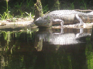
I paid a $3.00 plus tax, day use fee. I was glad it was not $6. The website says day use is $3 per person, or $6 car load, and $3.00 to launch. I emailed the Outpost a while back and was told both fees had to be paid. I asked if there was an additional launch fee and was told the State, from whom the site is leased, said they can't charge a launch fee. They can and do charge a fee to park a trailer. So us car-topping paddlers are ok. The ramp is concrete, I put in next to it, a dirt area, just before 1 pm. An alligator floated nearby.

Fisheating Creek is a blackwater stream, fed by rain, not springs. Being my first time on the Creek, I don't know what "normal" water is. From water marks on trees, it was not as high as it has been, but from how it flowed into the cypress forest, not as low either.


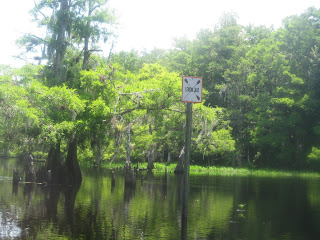
 Not having a hawk eye, directional signs on the Creek are a big help in areas where the Creek splits in two, or three. I came to one junction and went the wrong way. Good place for a marker, I thought as I got back on course.
There was a pole, but someone or something removed the directional arrow. I saw only two someones on the Creek. Two guys fishing (Aside, just now on A Prairie Home Companion, Elvin Bishop is singing about fishing). I saw a few more alligators, wood ducks, a swallowtail kite. According to the brochure and map I was given when I paid for parking, Fisheating Creek is "an important late summer staging are for these birds as they prepare for their migration to South America in August" I may have seen more birds, but there were not a lot on a hot June day. Not to mention, I'm composing this Tale 3 days after the fact.


Not a lot of big animals, but many butterflies and bromeliads.


I thought I'd paddle for about two hours, then turn back. I hoped to check out some of the primitive campsites on the Creek. On the map, the first site as you paddle up Creek is on the right side, at the end of an open area. I paddled through several open areas, the last one marked as Lemon Lake. Did not see any obvious campsites. Either I did not paddle long enough, or you camp wherever there is high, flat, dry ground, and the tent icons on the map are just suggestions.


I wonder if the wood frame above was part of the fencing built to block access to the Creek back in 1989? It is where I turned around, at 2:45, just past the west end of Lemon Lake.

 Padddling round a bend, I heard a splash, had to be a gator. Then I heard what sounded like bones cracking. Finally I saw the gator, jaws wide open, whatever it just crunched on the way to its stomach.
 Fisheating Creek is very isolated. Fort Myers, 45 miles away, is the closest place with any population. It's 132 miles from my house. I think I'll return.

Maybe I'll camp in the fall. I saw there is no reason to pay extra for a waterfront site. Can't launch unless you want to climb over the riprap. On the other hand, I'll probably camp down the Creek, wherever those sites are. The pictured tent is the only one I saw. There was one other car in the parking lot. Monroe County tag. That's the Keys. Where I began my five day weekend. Where I'll return, next Friday. For my nephew's wedding. On a sailboat. I'll bring the kayak.


No comments:
Post a Comment