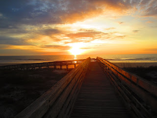
One person at the beach. The neighbor who was at the sunset. Too early for his adolescent boys, who had been talking, quietly, late into the evening.
Walking west
A look back east
Walk/Bike path. I am not sure how far the park road goes. There also is a paved trail about a mile north of the main entrance. I think that is 2.5 miles, on the east side of A1A. Well hidden from the road, except for two parking areas.
Camp road9:25, time for a walk
This high mound is near my campsite. I wondered it it was in Indian shell mound
Start of a hiking trail
The above sign neglects to mention the being at the top of the food chain. The mosquito. They were present, but not in great numbers.
Dryer and big sink for dish washing at the restrooms. There is also a washing machine. There are two bath houses at the campground. I made the short drive to Myrtle Creek. Before launching, I saw a couple packing their truck With a coffee maker. I told them I was going to bring one, next time. They said, "$14.99, just leave it with the camping gear" Sounds like rich people talk, I thought. I'll just bring the one from the kitchen.
On the water at 9:45. Paddled northThis looks like a shell mound
Osprey
As on Saturday, not much wildlife, but I enjoyed 2 hours on the water. Saw just two other boats, kayak and canoe.
Landed about 11:50
Campsite wildlife. I struck camp, showered, and left at 12:55
Checkout is 1:00. I do not know, but I think if I had stayed, parked near the launch and gone kayaking, it would not have been an issue. But, I had other places in the area I wanted to explore. So, I headed south on A1A.
Tabby house ruins near the entrance to Fort George Island Cultural State Park. Just past here, the road forks. Left to the Kingsley Plantation, run by the National Park Service. I visited there years ago, so I went right, to Fort George. Time permitting, I could hit Kingsley, later.
There is a lot of history in the area, from Indian mounds to the landing of the French in 1562.
A monument to me
I went into the Ribault Club, a restored Roaring Twenties Lodge. Named for Jean Ribault, the French explorer of 1562.
A wise decision. Thunder crackled as I walked across the lawn. It began to pour when I was inside.
Historical time line.
Ballroom
Lots of standing water
I sat in an easy chair, asked the Ranger for a cigar and a brandy. Not available. A book about Jacksonville landmarks claims that a dune on the old golf course, at 65 feet, is the highest point on the coast south of Sandy Hook, NJ. Which can't be correct. Or why did the Wright Brothers choose Kitty Hawk to test their flying machine? I've been there. The Carolina dunes are much higher. I just did a little searching. Mount Cornelia is the highest point south of the Carolinas, not the Jersey shore. http://www.nps.gov/timu/historyculture/upload/saturiwa_trail_text.pdf
Although other another link has the south of Sandy Hook claim. As I said, having been to the Outer Banks, I know they are higher. I did not actually scale Mount Cornelia, due to the rain. Which let up, giving me a chance to go to the car.
Peacock. What is this, Winter Park? The same Rollins that Rollins College in Winter Park is named for bought Fort George Island after the Civil War.
I headed home. Across the St. Johns on the Napoleon Bonaparte Broward Bridge. NBB was Sheriff of Duval County and Governor at the turn the 20th Century
An hour 45 minutes later, crossing the St. Johns in Sanford. I brought the rain with me, but not until I got the kayak and bike off the car and in the garage. Good thing I got an early start with the sunrise.


No comments:
Post a Comment