The moon was still high in the sky
Had to wait for old sol to climb over the cloud bank.
Back to my campsite
Cooked the last of the ground chuck and had a couple burritos.
I got the coffee brewing much faster than on previous camping breakfasts. Thanks to a cheap little grill screen (not shown here) that I put directly on the coals and logs. Worked great for flame broiled burgers, too.
Not a bad breakfast view. I cleaned up a bit, and got on the bike to ride to Flagler Beach. The town.
Three miles north of Gamble Rogers on a wide,concrete sidewalk on the west side og A1A. I had not pedaled it since 2006, or maybe 2005.
You can't miss Flagler Beach
The sign is at the entrance to the pier.
$1.50 to walk out on the pier. I splurged.
Red flag means high hazard. Or, lets surf!
I only saw one guy ride a wave. Pretty big break, the pier was moving.
Back on the bike. Rode into town, looking for interesting stuff
The museum was closed.
Even the Police Station has a bright "Old Florida", look.
I saw a sign for the Betty Steflik Preserve. No idea what it was. Went to find it. I always like a dirt road, not shown, into a park.
Always need to walk a boardwalk.
The boardwalk leads to a dock on the Intracoastal.
One guy was fishing.
A shelter. Handy in summertime heat and thunderstorms. The boardwalk did not just have an east west route, but past the shelter, had a southbound path.
A decent walk to another parking area.
With grills, picnic shelter, playground, and more
Back on the boards.
I returned to the crossroad or crossboardwalk, and continued northbound.
Now on a trail
That leads to a boat ramp on the Intracoastal
Back to my bike
Betty Steflkik was a Flagler County Commissioner. She was instumental in leading an effort to preserve this area. Some idiot wanting to build a shopping center.
The dirt road heading out.
What a great place. I wanted to find out more about it. Florida Hikes is a great resource. I just did something I should have done long ago. Added to the links on the right side of Dave's Yak Tales.
Back to the Atlantic side of town
Northbound locations
My bike makes it even more scenic.
Veterans Memorial Park
I have dined at the boarded up restaurant before. I wonder what happened.
Southbound locations. Add Gamble Rogers 3.
I found the answer to what happened to the Flagler-Pier-restaurant-
The pirates need to sack the place below
What an asshole. No need to build three stories, as there is nothing between the lot and the ocean. If the owner has to be pretentious, just add lions like the neighbors
This place is just north of the Park entrance. A rainy day dining option when camping.
I wondered where the 50K, thats about 31 miles, would be run. Its a small Park. I found the race website. 26 laps on the 1.2 mile nature trail.
Campsite views
From the picnic table as I enjoyed cold chicken and a PBR
Of the 34 campsites, mine was the only one with just a tent. But everyone was nice'. Had a couple nice chats with Gary and Delys
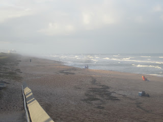
Final beach visit
As a camper, that is. Had to be out of the site at 1:00
Still looking for my first whale
Looking north from my site. The building is the day use restroom
Looking south. Campers restroom. Three showers in the men's. I assume the same in the ladies. Plus a unisex handicap shower. Not the prettiest campground if you are not looking east. But, and feel free to correct me if I am wrong, it may be only oceanfront State campground on mainland Florida. Perhaps there are some in the Amelia Island area. Campsites in the Florida Keys, at Long Key, Curry Hammock and Bahia Honda State Parks are on the water, but due to the reef, you don't get the crashing waves.
Put the kayak in on the Intracostal side of the park at 1:10
Paddled north, into the wind and current. Or was it the tide?
The ICW is wide, but there were inlets and small bays to explore
The tide does come in and out, and there are sharp oyster shells, so be careful when exploring.
I was wondering if I would make it to the dock I walked on in the morning. I did not even see it. My camera on max zoom is better than my eyes. I see it in the photo. I turned back here. Sort of. Entered a large bay on the east side of the waterway.
Wonder if this is a dune, midden, or modern trash dump. No gulls and vultures, so likely not a dump. I'll go with dune. A long way off. The only kayakers I saw headed towards the east shore, but it was time for me to head back south to Gamble Rogers
Highlight of the paddle. A loon. Something I do not see very often. As compared to say dolphins. One surfaced near the loon. Of course, my battery chose to expire. My the time I replaced it, the dolphin was gone.
There were several built up spoil areas at the end of side canals
I am sure some want all the canals to look like the one below.
Give me the empty ones. Which from a flooding, hurricane, insurance perspective, makes more sense.
Saw a second dolphin. No battery excuse this time, but no photo
Landed at 3:40
Loaded the yak and crossed A1A
Chasing a rainbow
The Recreation Area was the location of an Air Warning Site in WWII
Leaving Gamble Rogers, looking east, into the sun, towards the Intracoastal, 4:26 PM
12 minutes later I stopped at North Peninsula State Park
Which is south of Gamble Rogers
2 and a half miles of oceanfront. No entry fee which explains why there are more people on the beach here than there wear at Gamble Rogers where my car was the only one in the day use lot. No parking lot here, a few spaces on A1A and Highbridge Road.
Driving under moss draped live oaks to see the Fairchild Oak
Not this one
Nor this
The Fairchild Oak
A branch that goes into the ground, and back to the sky.
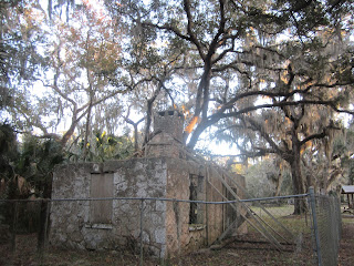
This coquina stone building, built in 1915, was a land sales office.
I was looking for tiny, seepage springs. I recall seeing them back in 2005. Perhaps they are in another section of Bulow Creek State Park
This big sinkhole was hard to miss. Much better in person, check it out for yourself.
A few weeks ago, this question was posed on the Green Wave Forum:
is there a good spot in the Merrit Island/Cape Canaveral area that has
a very localized combination of Kayak/camping and a relaxed seaside
strip like Main street in Cedar Key?
a very localized combination of Kayak/camping and a relaxed seaside
strip like Main street in Cedar Key?
My answer was no, but New Smyrna Beach and St. Augustine may come close. After my camping weekend, I will say that while no Cedar Key, Flagler Beach is the closest thing on the Atlantic side of Florida. Here is the entire thread. http://www.clubkayak.com/greenwave/default.asp?message=10790
Last photo of the weekend, 5:07 PM Sunday. Dave's Yak Tales of the weekend completed, 8:53 PM Thursday. With no computer or blogger issue. I must have seen a lot. Now, you have too.














3 comments:
Is that what I think? (Talking about the chair)
Luis, I did not realize, until now, that it looks like the Puerto Rican flag. It came in a stars, as in more than one, and stripes, case.
What I really want is a little Wisconsin flag to hang from my rear view mirror.
Well, it looks pretty but that is just my opinion. You know, may be a little biased.
Post a Comment