Dave's Yak Tales

Cedar Key Sunset

Sunday, March 22, 2009

Econlockhatchee River

Sunday, March 22, 2009 I kayaked the 8 mile portion of the Econ from 419 to Snow Hill Road. Did the car-bike shuttle. With the back seat folded down, my bike fits in the new Versa. No need to remove the front wheel. To put it in the car. I did remove the wheel at Snow Hill Road to change the tube. The one on the Trek had a slow leak. Somewhere in that process my trip odometer fell off. I walked back and forth along the side of Snow Hill, where I had twice pumped up the tire before changing it. To no avail.


Not having the odometer, which also is my watch, I made sure I took a picture as soon as I was on the River to record the time. 10:59.


On reason I chose to paddle the Econ today was another windy day was in store. 15 mph from the north. I figured the high banks of the Econ would block some of the breeze. Other then sections where the River flows due north on its north east track, the plan worked. I also had the wind at my back for the first third of the 5 mile plus bike ride from Snow Hill to 419.


The banks are higher than usual, or rather the water lower. Another week without rain and the this section of the Econ may be impassable. I scrapped the sandy bottom several times. Thank goodness for two piece paddles. Good for pushing. At one point I had to get out and walk.


Look at the top photo. See the turtle ? Now you have perspective on the height of the banks. This section is the highest on the Econ.


Here is a more typical section.


Lots of downed trees, but other than the portage previously mentioned, I always found a path through areas like this.


I paddled 30 minutes before I saw my first bird, this great blue heron.


I know. I failed to get all of the head. I did get all of the head in my next picture.


I missed capturing the first eagle I saw. Just after the great blue blue heron. Looking in a tree, thinking "that's a big bird." Then the not yet mature bald eagle took off, white feathers starting to come in on the head and tail. A few minute later, this one flew overhead, before perching. Note the blue sky. This shot, like the first was taken at 11:50. Clouds. I told you it was windy.


I saw bald eagles, likely the same ones, several more times during the afternoon. No more pictures. Bald eagle pictures, that is.


Turtles and other, larger, reptiles.


I had good views of 3 alligators, all big. Two more splashing into the water as I approached. All in the same type of environment. Bends in the Econ with deep water and banks or logs to sun.


In addition to the great blue heron and bald eagle already shown, birds seen were vultures, great egret, red shouldered hawks, blur herons and limpkins. Final two seen here.


Just three other paddlers during the first two hours. Further downstream, a few more, including two groups, one with three kayaks, the other with three and a canoe, at the Flagler Trail Bridge.


I took a break, then was on my way, landing at 2:29.


A pleasant 3 and a half hours on the Econlockhatchee River. To top off the day, I found the bike odometer.

Saturday, March 21, 2009

Rock Springs Run

INSERT PHOTO HERE


As I drove through the gate at Wekiwa Springs State Park this morning, Saturday, March 21, 2009. I realized I left the camera at home. I briefly thought of going home to retrieve it, but that would defeat the purpose of getting out of bed and to the Park early. Which is, get out before anyone but wildlife is out and about.

I was on the Wekiva River at 7:30. No clouds, no wind. Looking out my window now, 3 pm, the palm fronds are swaying, but I don't think the forecast 20mph wind has arrived.

Down the Wekiva to Rocks Springs Run. Paddled up the Run until 10 am, than turned around. A short trip, figured without the camera may as well get home and watch some hoops. Too bad the Warriors and Badgers aren't playing today.

Campers were at Otter and Indian Mound. I did not see my first downstream canoers until I was upstream of the Big Buck Campsite. To the first party I said, "You must have been waiting for them to open" "We were". The second canoe I saw just before 10, my planned turn around time. I took it easy on the way back so not to overtake them. Saw a deer on the left bank between Indian Mound and Big Buck. I would not have been able to get a picture, it was too far way, disappearing into the woods.

Bird list: Blue heron, great blue heron, tri colored heron, yellow crowned night heron, ibis, great egret, belted kingfisher, red shouldered hawk, osprey, barred owl, swallowtail kite. limpkins, anhingas, mallards, wood ducks, unseen woodpeckers tapping, and, as always, vultures.

Turtles under the clear water and later, sunning on logs. One alligator, in the algae on the right side of the lagoon.

INSERT DEER PHOTO HERE
Two deer, mother and yearling. Possibly the same two picture in this Tale
In the same general area, today upstream of Buffalo Tram. Could have had several good shots, as I sat in the yak, the deer 10 yards away, raised my hands in an imaginary camera saying, "click, click , click, click" until the deer slowly moved on.
I now began to encounter folks coming up stream from the Park and Wekiva Marina. Back to the Wekiva, the Saturday crowds were building. I landed, at 12:45. Dragged, then carried the yak over the new pavers, the planted rye grass is coming through, not to much, we need rain, than dragged it across the lose dirt up the remainder of the hill to the car.
No snorkel, the Spring looked crowded. In a few weeks, crowded or not, I'll be taking advantage of the Spring to cool off.
I just put the camera in the car, so tomorrow, from a yet to be determined location, I'll have photos.

Sunday, March 15, 2009

Haulover Canal Discovery Launch


I watched Space Shuttle Discovery blast off this evening, Sunday, March 15, 2009. Last November's launch of Endeavor was the final scheduled night time launch. Emphasis on scheduled. Discovery was delayed several times. Lucky for me, it finally went of on a weekend, so I got to see it from the kayak.


As usual on launch day, I took the longer but less congested route to the Canal. East on Interstate 4, east on State Highway 44, south on I-95, east on County Highway 442, South on US 1, south on State Highway 3 to the Canal. I was in the Indian River just before 3:00 and headed out to Mullet Head Island.


Birds packed the refuge island. Pictured are rosette spoonbills, pelicans and cormorants. Also roosting and or passing overhead were ibis, great blue herons, great egrets, reddish egrets and more. The birds were flying more then they should. Some illiterate yahoos were wading, well inside the "Nesting Area No Entry Beyond this Point Sign" I am continually amazed that people who can't read can afford boats.


I paddled from the west side of Mullet Head to a second, unnamed island in the River. Saw a dolphin in the distance, then a few seconds later, surfacing just a few paddle lengths in front of me. It swam under me, I turned to watch it, then continued. I circled the island. One crow. I wonder what makes Mullet Head so attractive to so many birds, while this one stands almost empty.


I made my way back east, exploring a series of small canals south of Haulover Canal. I've seen alligators and manatees here, none today. But, I had time to kill before the 7:43 lift off. Paddling beats what landlubbers have to deal with, as reported in Florida Today.


While drivers waited in traffic to get to a crowded park to wait in more lines, I paddled into "Dolphin Cove" and waited for one to surface.


Next stop, Bairs Cove, where manatees are always seen. Well, almost always. I wonder if the large, loud Coast Guard generator was keeping them away. Manatees go below when they hear engine noise, and perhaps the constant drone of the generator powering two campers- a mobile HQ, kept them out of the Cove.


More birds, great blue heron, pelicans, great egret.


I paddled east in the Canal, pausing at the Manatee Overlook. Finally saw a manatee, east of the of the Overlook. We both continued east. I lost it, distracted by a dolphin in the shallow bay on the north east end of the Canal.


I briefly entered the choppy Mosquito Lagoon, peering at the launch tower to the south. Back to the shelter of the canal, I paddled back west. Many kaykers in the water, heading east. I knew I had a lot of time before lift off. Saw the second manatee of the day, west of the Observation Deck, near the drawbridge.


Blue heron.


More kayaks in the water, individuals, groups 2 or 3, large tour groups. A van pulling a trailer loaded with yaks drove on the dirt road to the landing area. Seemed every outfitter in the area had a tour. I planned to stop at the launch, kayak, not space shuttle, eat, get bug spray, a flashlight and radio out of the car. But, the beach was jammed with kayaks. No room to land. So, I ventured into the Indian River, paddled south into a small canal. Here I ate in privacy. And saw this.


Mating horseshoe crabs. This was the second time I've seen this, the other was also near Haulover Canal. I reported that sighting to the Fish and Wildlife Commission.


http://research.myfwc.com/features/view_article.asp?id=18561 They are conducting a survey. I need to contact them again. I got back in the kayak, paddled up the side canal, and a horseshoe crab orgy was in process.


More like orgies. Several groups like the one above gyrating in the water near the bank. Quite a thing to see. I'm glad the crowd at the kayak launch area kept me away, or I would not have see this.


It was 7:00 PM, time to paddle the mile of Haulover Canal to Mosquito Lagoon.


Late light makes for good pictures.


Saw the third, and last manatee of the day. Near the Observation Deck. I turned to the west to catch the sunset


7:20, time to get to the end of the Canal for the launch. The Canal ends at the Mosquito Lagoon. Two small jettys, nothing more than piles of rocks, extend a short way into the Lagoon. I wedged the kayak next to a couple from Toronto. I've watched at least 3 launches from this position, for another I joined a crowd standing in the water just south of this spot, near the west bank of the Lagoon. No one was there. I asked the guy to my left if it was the wind, blowing from the south, that kept people from that spot, or the Coast Guard. "The Coast Guard". Haulover Canal is the line. No boats allowed past on launch day. Got to see the Coasties in action as a pontoon boat crossed the imaginary line. Whoooooo, the Coast Guard was on him in moments. Order restored, people with radios kept others posted of the countdown, until


Lift off !!!


I have no idea what the green thing is in some of the photos. Either some sort of reflection, or a UFO. I watched the booster rockets fall off, than using the Bill C. get away plan from the last launch, made my exit as everyone else watched the dot in the sky shrink. A last look at the contrail,colored by the final rays of the sun.

I took a video as the shuttle rumbled overhead. I thought the sound would come through. It did not. There is sound, me, and people in the background. The roar of Discovery did not come through.
My get away worked to perfection. As I paddled below the drawbridge, cars slowly moved across. A unique view of traffic is looking up through the metal grates. I was the first one back to the launch. Only two others arrived before I left. My that time, traffic had cleared. The only delay was where State Road 3 meets US 1. That was only a few minutes. I was home at 10:00.


Saturday, March 14, 2009

St Johns 2 and Econlockhatchee

The "2" should be raised, as in "St Johns Squared". Saturday, March 14, 2009, I learned State Road 46 in Seminole County crosses the St Johns River twice. My intent was to put in at 46, paddle up the St Johns to the Econ, up the Econ for 3-4 hours, than come back. I had never paddled the Econlockhatchee from the St Johns to Snow Hill Road. A fellow paddler emailed photos she took Thursday. Lots of bald eagles on the Econ, plus, white pelicans on the St Johns. That was enough for me to explore a new location. In a new car.
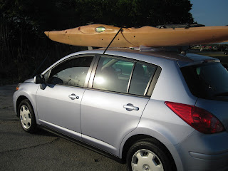


2009 Nissan Versa. 4 cylinders,5 doors, 6 speeds. Got it Thursday. Hope to get a rack soon. The roof on the '98 Cavalier was missing a little paint. The yak was at the local outdoors shop, getting patched. I had hoped to get a rack yesterday, they had none in stock, so I used the trusty pad and towel method. No scratches, so far. As for the patch, my old glue and duct tape method worked better. The guys at the shop said the damage was so bad they may not be able to fix it. I had them give it a shot. Oh well, I'll use the money I spent ($70.00) to negotiate a discount on a roof rack.

I arrived at the wrong bridge by turning left instead of right at the intersection of Seminole County 426 and State Highway 46. Not knowing then what I know now, I was launching at Cameron Wright Park. A new span is under construction.


The sediment barriers make fine perches for great blue, green heron, and snowy egret. Nice way to start, in the water at 8:25. I headed upstream, south on the St Johns. Equipped with a small map, I thought it would be easy to find the mouth of the Econ. Not so easy when you're on the wrong part of the River. Seeing a white pelican, I thought I was on track. The St Johns was shallow and muddy. Long grass cover banks. One clump of palms. Marking the Econ ? No flow, I kept south. Lots of alligators in the water, more on shore.


The River was very wide, my map indicated a narrow channel. It grew even wider, a highway bridge in the distance. I was at the north end of Lake Jessup. I kept going, as the birding was great. Great and snowy egrets, ibis, including glossy, and white pelicans.


A second great blue heron also had its head raised. No fish up there, fellas. But then, I assume one wasn't a fella, if you get my drift. Mating dance.
Speaking of drift, after 90 minutes, I turned around. Still searching for the Econ. It couldn't be two miles from the bridge, and I know I went more than two miles. I tried the cut at the palm trees. Straight as an arrow, stuck in muck. Had to be a canal. At home, looking at a Seminole County map, I see was in the Lake Jessup Conservation Area. Which has canals.


I landed at noon.


See the airboat on bank, left ? The driver asked if I was worried about alligators. My response was no, but those things, (airboats) terrify me. Assuming he had been on the River before,I asked for far it was to the Econlockhatchee. "16 miles" What ? I showed him my map,and that's when I learned about the two bridges. Nice guy, offered to help carry the yak to the car. I declined the offer. I guess all airboat people aren't bad. Later, on the Econ, I encountered 6 of the obnoxious machines. All jerks, not slowing down. Loud, wake making, fume spewing pieces of crap. If I were king, I'd ban them outright. As a start, I'd outlaw the use of earplugs by airboat users. Let them hear the racket.

Yak on the car, I drove to CS Lee Park. Went the wrong way first. Didn't get back in the water until 1:45 or so. . CS Lee appears to be a popular spot with air boaters. A truck had a "Seminole Airboat Club" sticker on its window. Curious, I googled it. Had to chuckle when I read this on the home page.


"Our club is made up of dedicated members that take pride in the preservation of our environment & keeping our waterways clean and safe."


Sounds of nature are part of the environment. Can't hear them in an air boat.


Here is the launch area, photo taken at end of the day.


In the St Johns, I paddled a short way upstream, easily finding the mouth of the Econ. The St Johns is much narrower here than it is near Lake Jessup. Banks are sandy, in contrast to grass up to water's edge. Along the Econ, near the St Johns, the grass is short, cattle pasture.


The Econ twists and turns, past white sand banks, eventually more and more trees appear. Cattle were in the woods, coming down to the bank. They are more agile then I thought, climbing up and down.


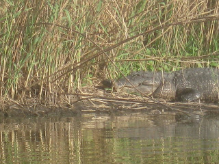
I saw several alligators that appeared big enough to take a steer. No good pictures of the big ones.


Here are some little guys.


Napping, not snapping, turtle.


This great blue heron shot turned out well.


I was paddling until three or I saw an eagle, which ever came first. It got to 3:25, and I turned around, no eagles. The upstream view at my turn around.


I stopped to empty water from the kayak. Much of the land on this section of the Econ is posted, "No Trespassing". I did not see a sign where I stopped. Back in the yak, I saw two bald eagles high overhead. Far enough that I thought I could be mistaking vultures or ospreys for eagles. But, soon I saw another, lower. Confirmed bald eagle. Then, the "woosh woosh" of large wings overhead. Two bald eagles flying low. One briefly landed. You see it in the opening photo.


I made a second stop to check out this shelter.


As I approached it on the way upstream, I figured it was a private structure, maybe an elaborate deer stand. I was wrong. The Cul Pepper Bend shelter is provided by the St Johns River Water Management District for public use. Two picnic tables are inside. Here are two views from the shelter.


It took me an hour to return the launch, with photo opps on the way.


Wood storks, great blue heron, and flock of white pelicans.


I got the yak on the new ride.


Tying the front last, moving the car to get away from a sunning snake.
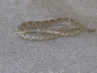


I have no idea what kind it is, better safe than sorry.
A another great day on the water. Two new places, big alligators, bald eagles, white pelicans. If not for airboats, it would have been perfect. With the exception of the gentleman who got me to the correct bridge.

If you are reading this Sunday afternoon, March 15, and see the Tale has just been updated, you may be wondering, why isn't Dave in his kayak ? Because, Space Shuttle Discovery is set for liftoff in 7 hours, 18 minutes, 20, no 19, no 18 seconds. 7:43 PM. I'm off to Haulover Canal. Hopefully, I'll post a picture or two around 11:00 PM EDT

If you want more of this Tale, including a map, click http://www.clubkayak.com/greenwave/treports.asp?trip=338 for my Green Wave Forum trip report.