Dave's Yak Tales

Cedar Key Sunset

Monday, June 8, 2009

Lake Park to Cedar Lake

My mom lives very near Lake Park, one of the world's best, in my opinion. Designed by Frederick Law Olmstead, who also designed some park back east, Center Park, or Mid town or something like that. He had a lot more to work with on the shores of Lake Michigan, then on a narrow island shadowed by skyscrapers.


I took a walk in the Park Friday morning, June 5, 2009. Lake Park is fortunate to have active volunteers, in an affluent neighborhood.
I always assumed green was the natural color for General Woolcot.


North Point Lighthouse, through the trees and crane restoring the Lion Bridge.


Another pedestrian bridge in the Park.


Indian burial site. I removed my cap.


My plan was to walk to the pavilion, down the steps, and head back on Lincoln Memorial Drive. But, inside the Pavilion I saw a sign stating the Lion Bridge was being repaired, so I had to investigate. The "Waterfall Ravine Project" sign also caught my attention, so I had to check that out.


My Mom remembers the old waterfall. I don't. Should be nice when it is complete. A trail leads done the bluff along the falls to Lincoln Memorial Drive. Views from LMD.


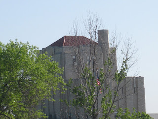
Linwood Ave Water Purification Plant
Wildflowers


Snake Hill

Staircase to the Pavilion


Lake Michigan.

I took another trail back up the ravine.


To the park section of Lake Park. Cut grass, ect--although my Mom tells me they don't cut it as much as they used to and do nothing about the dandelions.


Back to Mom's.

Where I had breakfast, did a few chores,then waited for Steve R. to come by. Tom M picked us up and it was off to Jeff P's Cedar Lake cottage.
Kevin K and Jeff.

Three more days to write about. Stay tuned.

A Great Place on a Great Lake

That was a slogan my hometown had a few years ago. I was back for an annual visit from Thursday, June 4 to Monday June 8, 2008. I got in a kayak on two of the days, but all were enjoyable. And I plan to report on each day. Wheter or not you read is up to you. You can always just scroll and stop at interesting pictures.


Brother Pete picked me up at Billy Mitchell, and took me to the St. Francis Brew Pub. A spanking new building. Having no brew pubs in Orlando, it was a welcome "Welcome Home".


After a couple brews and warm pretzels--with awesome dipping mustard--- we drove to see Pete's sailboat at South Shore Yacht Club. Well, not quite to the SSYC. We parked off S. Superior street, and scrambled down the bluff to an asphalt bike path on the edge of Lake Michigan. We had a nice stroll north, maybe a mile. Being a Shorewoodian, it was nice to get the Bay View perspective.


Pete left his boat keys in the car, so we just sat on the boat. This bird is happy we did not cast off.


I leave Central Florida but can't shake the Mouse.

When I was a kid, I never saw Canadian geese. It was not until the early 1980's that they began hanging out in Milwaukee. I saw them then on the Milwaukee River when I worked at The Anchorage, a restaurant, not a mooring spot. You will see The Anchorage later in this Milwaukee area tour. Much later, from Monday the 8th, and we are at the 4th of June now.


Milwaukee through the masts.


I framed my brother.

Inside the South Shore Bath House. Built in the 1930's with New Deal money and labor. Today, we call it "Federal Stimulus"

We returned to the Pete's pickup via a gently sloping asphalt path, not the dirt trail we scrambled down. Superior Street scenics.


No visit to Bay View is complete without stopping at the Pryor Street Well. I copied this from the City of Milwaukee Water Works website:
"originally was an artesian well but now a pump brings water from the well to the tap. The underground water table supplying artesian pressure was drawn down during the 1980s, forcing the need for a pump.

The Milwaukee Water Works maintains the site of the well but does not treat the water. The Milwaukee Health Department periodically tests the well water. The well water is higher in iron and sulfates than city water, but has similar fluoride content. The Water Works recommends Milwaukee's high quality tap water, which is Lake Michigan water treated with ozone disinfection and biological filtration.

The Pryor Avenue Well dates back to 1883. The Milwaukee Historic Preservation Commission designated it a historic structure in 1987. The Pryor Avenue well is the only public open well operating in Milwaukee."

Pete filled his water bottle, and off we headed to familiar stomping grounds, the East Side. Bay View being, "The Other East Side"

Wisconsin's Flagship, the SV Denis Sullivan, was in port.


She was built just a few years ago, the first schooner built in Milwaukee in over 100 years. Pete, who has done some volunteer hours on her, tried to sweet talk out way on the vessel. No luck.


A few more Milwaukee landmarks. Cudahy Tower. The low good looking building. None of the other glass towers were around when Miltown was my home.

Calatrava addition to the Milwaukee Art Museum.


Wisconsin Gas Company. Before weather.com, the changing color of the flame gave the forecast.


"Gold means cold, blue, no changes due, red, warm weather ahead, agitation means precipitation"


We finished our Lakefront tour at the new and improved North Point eatery. Now run by the Bartalotta empire, the old building has fresh paint and good burgers, dogs, ect with all the trimmings. Tasty with a malt.


And a view from a Holstein painted picnic table.

Good boys that we are, we got a burger to go for our darling mother and delivered it to her home where I spent the night.

Tuesday, June 2, 2009

Rock Springs Run and Wekiva River

Paddled Rock Springs Run and the Wekiva River Tuesday morning, June 2, 2009. In May, I visited Wekiwa Springs State Park, once, probably a record for fewest visits. I was waiting for the waters to recede, and downed trees to me removed from Rock Springs Run. A fellow paddler sent me a picture last week of a fallen tree blocking the Run. I thought that perhaps the folks at Kings Landing would have removed it in time for last weekend so renter's would not complain and would return for another visit.


I was in the water at 8 am. Wekiva pics.


Into Rock Springs Run. The water higher and darker than my last visit, May 6. I came to a log with a fresh looking saw mark. Was this the downed tree? Continued upstream. A tree blocked the Run. Or so it seemed. I was able to duck below it and go through. Only to get perpendicular to the current and be swept down stream. Through an opening on east bank I had missed. Leave it to me to do things the hard way. I straighted out the yak, and continued up Run. Surely this was the tree I was told about. No, this is.


Downstream of Otter Camp. Just as I had been told. Not quite to the big hollow cypress tree. I might have fit under the highest part of the obstruction, but that would put me in a tangle of smaller branches. I looked for a way under, over or around. But, having to go to work later, I turned around.


Instead of doing the usual morning paddle past Indian Mound, I'd take the opportunity to paddle more of the Wekiva, downstream of the confluence.


The first picture of the great blue heron was taken on the way downstream, just before the bridge. It was still there on the return, 18 minutes later.


I almost got a tongue shot here as the GBH was doing the throat pulsing thing, usually seen with cormorants


Alligators.


I passed the Marina, now called "Wekiva Island" They are charging $100.00 a day of canoe rental. It does include a cooler with ice and 6 water bottles. I like it. Price gouging like that will mean less people.


The anhinga and turtles are on a log that is often occupied by a large alligator.


The Yak Dave wading bird sunning turtle = alligator matrix again proved accurate. The big gator was not on the log, but a smaller one was on the inside of the log, hidden in the greenery.


The gator is barely visible Follow the anhinga's tail. Click the pic for a larger view.

I landed at 10:50 or so, plenty of time for a refreshing swim before heading to work.


Programing note. I leave for Milwaukee, and an annual get together at Cedar Lake in Kiel, Wisconsin. Slow pontoon rides, around the lake, maybe a sail on Lake Michigan with my brother. Not likely to kayak--but, you never know. Back here Monday night.