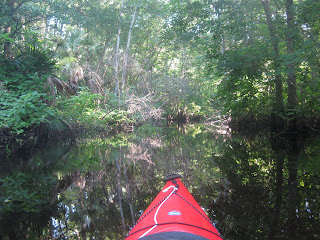
 The last kayak trip of the Independence Day weekend was a visit to the Lake Norris Conservation Area, on the southern edge of the Ocala National Forest. I decided not to go to Wekiwa Springs State Park and Rock Springs Run, for two reasons. (1) The up run paddle would be tough on Day 3, and , (2) Holiday crowds. Thanks to J.B. for putting the Lake Norris bug in my ear.


 The birds nest and perch in the hundreds of cypress trees that cover the shore, and more.
 Paddling through the cypress forest, so lush and green, I could smell it.
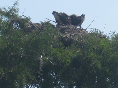
Usually, I see just one osprey in a nest. Often a second, I assume the mate, is in a nearby, higher perch. On the other hand, maybe the one out of the nest is waiting for a chance to steal the nest. I'm no osprey expert, but based on observation, I'd bet my first thought is the correct one. All the rambling for this picture.

I kayaked the entire Lake, on a counter clockwise course. I stayed close to shore, except at the southwest, and northeast corners, where I took a diagonal track. A paddler was on the Lake when I entered, but disappeared in the cypress trees. There is only one place that person could have landed, a cleared area that has a campsite and canoes. The canoes are locked up. Both available by contacting the Lake County Water Authority.
http://www.lcwa.org/index.asp?page=70
I did not see that paddler again. He/she must have landed, then paddled back to the launch site after I passed.
A Boy Scout Camp is on the north end of Lake Norris. I have never seen anyone there, until today. Two kids fishing. Usually I will turn back here, but today I kept going. The Lake tilts a bit to the northeast, I arrived on the opposite side from where I began around 10:50. I entered the Lake at 9:30. The view looking back to the southwest.
 As you can see, the Lake was not as smooth as it was when I began. The wind was out of the south, in my face. I had to work to get back. It took an hour. The east side of the Lake is not as nice as the west, it has about 20 homes, but still has some scenery.


 Here is the view looking back to the north after I completed the crossing. See the bubbles ? My paddle trail.
 Two paddlers came out of Blackwater Creek. That made 5 people I saw. Lake Norris is getting overrun. Down Blackwater Creek.
 To the put in, where I had to test the accuracy of this sign.
 More accurate then ever. I have paddled beyond the Lake Norris Road bridge, in the past. Not far, but a lot farther than today where a downed tree just downstream of the bridge had me turn back. A three hour paddle.
 As you can see, the Lake was not as smooth as it was when I began. The wind was out of the south, in my face. I had to work to get back. It took an hour. The east side of the Lake is not as nice as the west, it has about 20 homes, but still has some scenery.

 Here is the view looking back to the north after I completed the crossing. See the bubbles ? My paddle trail.
 Two paddlers came out of Blackwater Creek. That made 5 people I saw. Lake Norris is getting overrun. Down Blackwater Creek.
 To the put in, where I had to test the accuracy of this sign.
 More accurate then ever. I have paddled beyond the Lake Norris Road bridge, in the past. Not far, but a lot farther than today where a downed tree just downstream of the bridge had me turn back. A three hour paddle.


5 comments:
Nice pictures, I ran Lake Norris today,nice to see the trees green again, just a tight squeeze at one of the curves on the creek, a fallen tree that left very little clearance its always changing.
r/
Chief G.
Hi Dave,
We want to do Lake Norris again and was wondering about the water level in Blackwater Creek, is there anybody that can be called prior to going to see if one can get through the creek, I looked up the Boyscout Camp and one other # I found but got no answer, long way to go if we can't get through.
Thanks, mary
Mary, if a waterway was deep enough at the start of the month, it still is now. It's not like the summer thunderstorms have stopped. Of course, those same storms can topple trees. My advice, have a Plan B. Go to Alexander or Wekiva Springs,if you can't get through, to name two examples.
Add this site to your favorites http://waterdata.usgs.gov/fl/
You'll need to search it, can't put links in the Comments.
Thanks Dave, you are a great resource for us newbies!
Mary
You're welcome Mary. I just re-read the Tale, the link to the Lake County Water Authority has links to water level data.
Post a Comment