
 Believe it or not, there is a spring fed stream in Central Florida that I had not paddled until today, Saturday, March 27, 2010, Gum Slough. I have kayaked in the Atlantic, the Gulf, bays, sounds, lagoons, rivers, creeks, canals, even a bight, but this is the first time I've paddled a "slough" Here's the definition from Merriam Webster:
Main Entry: slough
Pronunciation: \ˈslü, ˈslau̇; in the US (exc New England) ˈslü is usual for sense 1 with those to whom the sense is familiar; British usually ˈslau̇ for both senses\
Function: noun
Etymology: Middle English sloughe, slo, from Old English slōh; akin to Middle High German slouche ditch
Date: before 12th century
1 a : a place of deep mud or mire balso slew or slue \ˈslü\ (1) : swamp (2) : an inlet on a river; also : backwater (3) : a creek in a marsh or tide flat
I think it is misnamed. Hardly a place of mud or mire, Gum Slough is a short, 4.5 mile, scenic, spring fed stream. I have read about it for years. Reports indicated it can be a difficult paddle, especialy when the water level is low. Felled trees create challenges to go over, around, or through. The Slough twists and braids into several channels, finding the correct one can be difficult, or so I read. Recent reports, however indicatied no problems paddling Gum Slough after much recent rain. So, I drove towards Inverness, Florida.
State Road 44 West from the Turnpike, into Citrus County, through downtown Inverness, past the old courthouse, Lake Tsala Apopka, to County Road 581/Turner Camp Road, folllowing the route of Hernando de Soto.
"Hernando DeSoto faced some of the greatest hardship of his 1539 expedition in these swamps. Some archaeologists believe their Indian guides deliberately led the Spaniards through the extremely inhospitable Tsala Apopka wetlands, through which you pass as you drive out Turner Camp Road from Inverness to the launch site. In fact, it's believed the path they followed closely paralleled Turner Camp Road. The Spaniards destination was the nearby Timucua village of Ocale, where they hoped large stores of corn would sustain them through the winter. Ocale, however, wasn't nearly as rich a village as other tribes had proclaimed, so DeSoto soon moved on to make winter quarters at a village located near today's downtown Tallahassee. One clue to DeSoto's having passed close to this area, was the discovery of some Spanish artifacts in a nearby Indian mound."
The quote comes from the Adventure Outpost site. Check them out for guided tours all over North Central Florida. http://www.adventureoutpost.net/index.html
Turner Camp Road ends at a public boat ramp on the Withlacoochee River. Here is a picture I took at the end of the day.

I was the only car in the lot when I shoved off at 8:45. Left turn from the ramp, downriver. There are a few homes on the left bank, and Turner's Fish Camp. I've read you can launch from the Fish Camp.


Gum Slough enters the Withlacoochee from the right, a fifteen, twenty minute paddle from the launch. Easy to find, even though I cheated. Brought the GPS, just in case. It showed a thin blue line entering the wide blue of the With. Had to be Gum Slough.
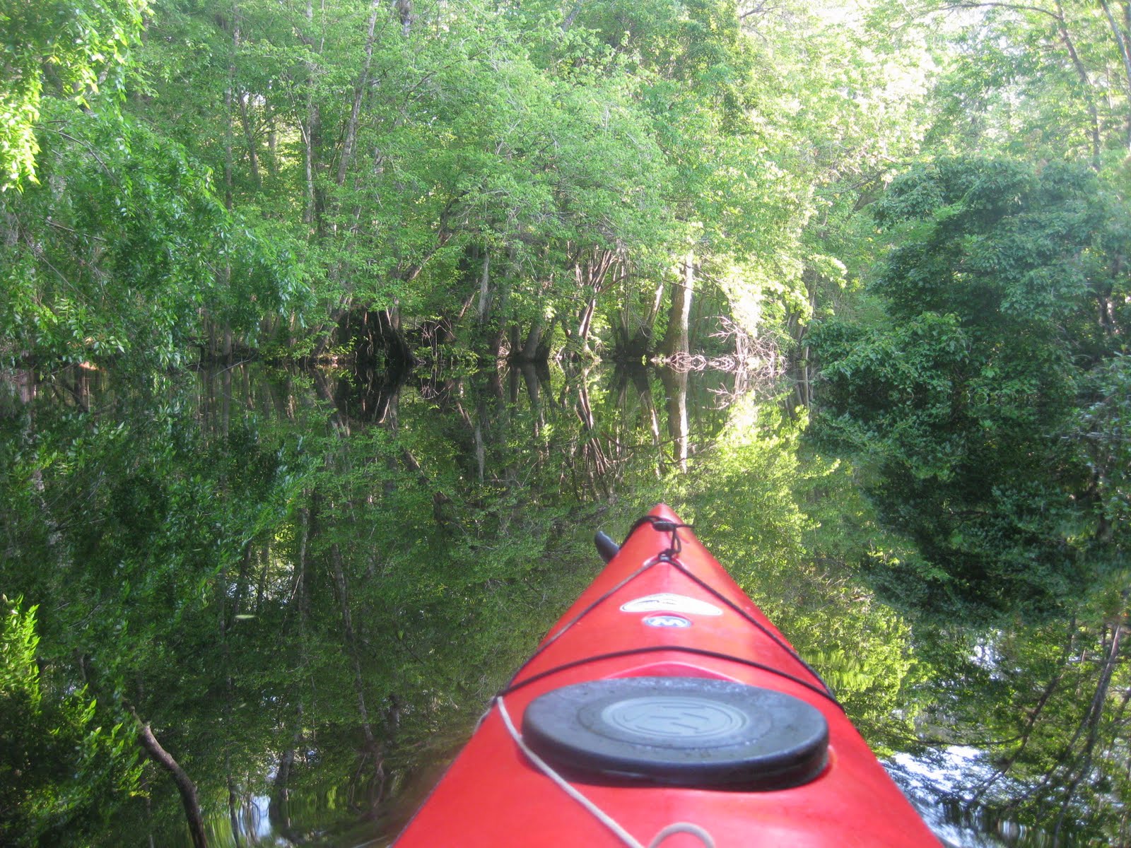


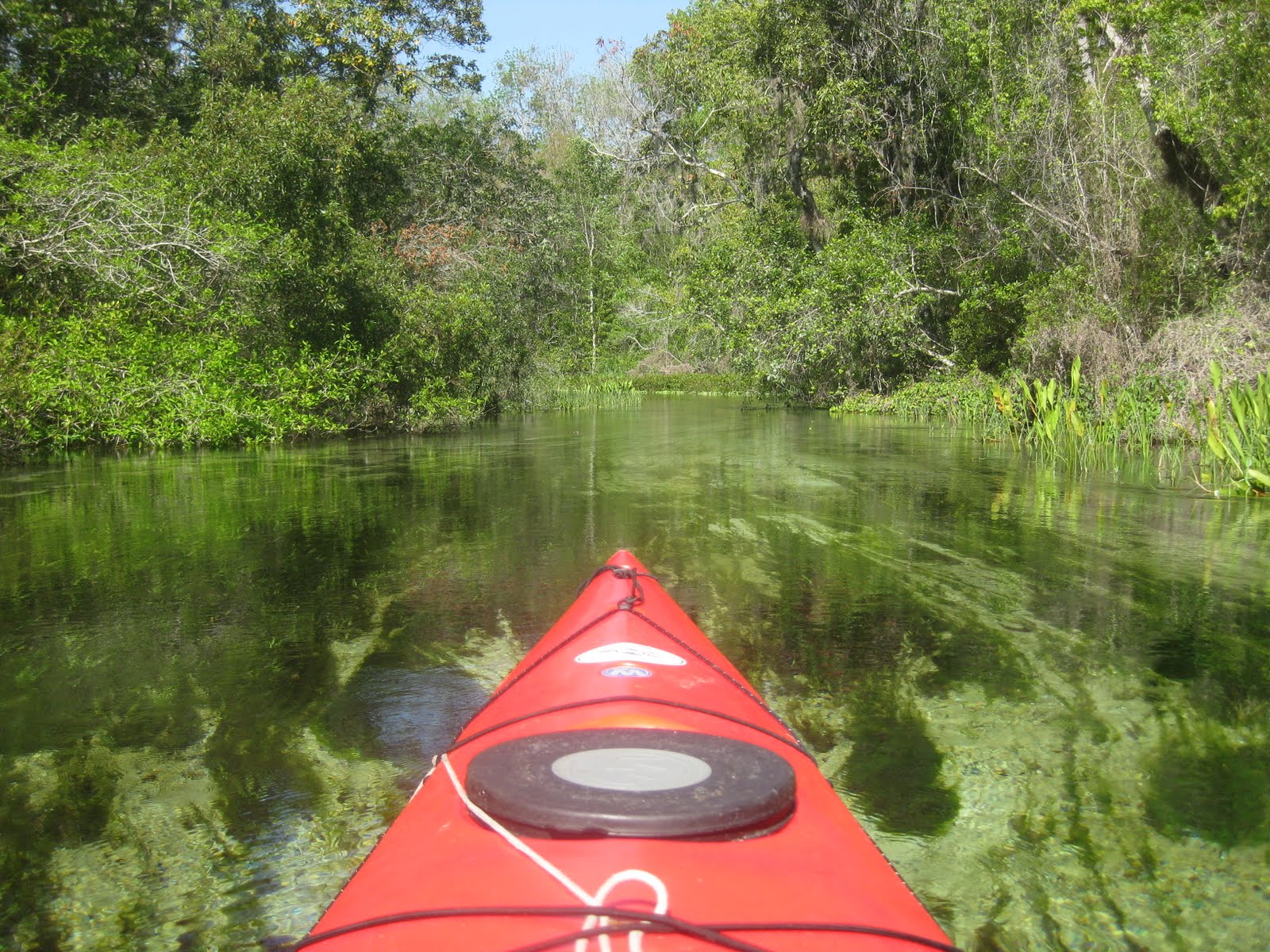
It was. I was immediately impressed as I paddled up slough, through a cypress forest, water flowing deep into the trees on either side. After a while, the banks get a little higher. I saw a some wild turkeys. The current, easy at first, increased as I got further upstream. The landscape changed again. Open, marshy areas. The change in landscapes is similar to Rock Springs Run and Juniper Creek, two other narrow, spring fed waterways.
There was just one point where I had to scooh over a log, There were several spots where I had to pick a channel. Judging the current, looking ahead as far as I could, I picked the correct path every time but one. And then, I quickly backed up and entered the correct channel.

Most of the banks are pubilc land. Either Fish and Wildlife or Southwest Florida Water Management. One private home is on left bank. Two more houses are at the source of Gum Slough. One of the sources. I saw the homes, and a spring pool, but also saw that a run led to another spring.


 I was over a beutiful spring. A wood fence is on the right bank, extending from the homes. I wondered if the same landowner controls the left side. A slooping bank, should I land and snorkel ? Decided not to, drifted back down the run to check out the springs in front of the homes.

I could hear people talking inside a screened porch. If they came out, I was going to ask about swimming in the spring away from the houses. They did not come out. I went back to the other spring.
 Again, I contemplated going in. Decided againist it. Next time, I'll bring and anchor, so I won't worry about tresspassing, and a second shirt, in case the one I'm wearing gets to wet. On the other hand, maybe it's a good idea I did not enter Alligator Spring.
"Spring Description
The authors have not visited this spring, so rely on the description by Champion & Starks:
Alligator Spring (Gum Spring 01A) is located in dense swamp woods on the Mation - Sumter County line. The spring pool is about 50 feet in diameter. The edge of the vent is about 6 feet from the pool surface and is 20 feet in diameter. Spring flow emanates from under a rock ledge on the north side and near the bottom of a circular vent in the central part of the pool. The run, which is the uppermost reach of Gum Slough, bends wouthwest about 500 feet. There is a large 10-foot alligator that lies at the bottom of the pool, and has been there every time the spring has been visited for sampling (May 2001, p. 86)."
Thanks to the Springs Fever site for the description. http://springsfever.org/
It took about 2.5 hours to reach the springs. After exploring for fifteen minute or so, I headed down the Slough.


I did not get many wildlife pics, so you'll have to settle for Slough scenics.

 . According to Springs Fever, two springs are a half mile down stream from the source. I found one.
"Live", a boil could be seen where the paddle is, and I could see down into the vent, 15 feet or so beneath the surface.


I'm glad I finally made it to Gum Slough. It is beautiful. With no people, just the way I like it. No outfitter or launch site at or near the headsprings like Juniper Creek and Rock Springs Run. Impressive amounts of eel grass and other underwater vegetaition, its not torn put by lots of paddlers, tubers and boaters. My biggest fear was an airboater would take advantage of the high water and come up the Slough, thankfully none of those evil contrapions did.


I drifted downstream, daydreaming, thinking there has to be deer here, so similar to Rock Springs Run, Juniper Creek, the Ichetucknee River, but no people!!. And its not so hard. Then I came to a downed tree. Got over it, and told myself I had encounterd it on the way up. Another barrier. I turned aroound, paddled up stream, came to the fork ans now chose the other route. It was narrow. Had the way up been this narrow? I saw depth markers every 30 yards or so. Don't remember these. And more partial blockages. Made it over all, but obviously I was in a dofferent channel. From the ribbons tied to trees I saw I was not the first one who went this way. So, I kept going, assmuming this side creek would eventually join the main flow.


It did, through a bramble of branches. I backed up, and pushed the yak over a partaiy submerged spit of land between the two channels.


 Did not see any alligators.
  Birds, in addition to those pictured or mentioned, great egret, tri colored heron and belted kingfishers. Not a lot of wildlife, but stilll, this is a great paddle. The only drawback, airboats on the Withlacoochee, which I returned to as 2:20. Why the bleep would anyone want to ride one of those ear splitting, wind blowing, gas guzzling, POS?
There is a campground on the right bank of the WIthlacoochee, just upstream of the Gum Slough entrance. It was empty. I stopped to check it out.


The sites are free, all you need to do is contact swfwmd for a permit. I may have to do that. On the other hand, maybe they're empty due to the airboat noise. I will be camping this coming weekend in the Seminole State Forest' along Blackwater Creek. Same place I was Christmas Eve. Did not realize its Holy Saturday. That's probabl why its available. So, my three camoing weekends will be Halloween, Christmas, and Easter.
 I landed shortly before 3. Six hours at a new, for me, location. I'll be back.
14 comments:
Hadn't ever heard of this one either. Looked like a nice run and an even better camping spot!
Thanks Dave for another great spot to explore. I'm so excited to share this with the group. Happy Paddling, Teresa
Last time I was there the water level was way up and the air boats were working their way up steam with chain saws. Glad to see that that activity has not spoiled the beauty of the place. Does anyone know of a site to go to for checking the water levels in the adjacent portion of the river?
JB, try this
http://waterdata.usgs.gov/fl/nwis/uv/?site_no=02312764&PARAmeter_cd=00065,00060
I've been to Gum Slough many times and always enjoyed the trip. I usually camp at Potts Preserve right across from the entrance to Gum Slough so I can get an early start and have a place to rest when finished. Was camping there 3 days this week but the ground is saturated and my Escape got stuck in the mud. Another nice trip from here is to Blue Hole about 4.5 miles north on Withlacoochee. What a great spring. Dave, what type camera do you use. You shoot some great photos.
Brian, I think I'll wait to camp when the weather is cooler and drier. On the other hand, I bet you had the place to yourself. I'll have to check out Blue Hole. My camera is a Canon Powershot SD1100.
My wife and I tried to kayak to the head spring on Gum Slough a couple of weeks ago. However, due to very low water we just could not make it. There were too many blockages along the way and portaging was going to become a monotonous mess. So we turned around and headed back to the With.
One of the rangers at Rainbow Springs SP told us that the local paddling clubs intentionally keep the slough hard to manage to keep the motorboats out. They do some pruning and cutting of logs, but leave enough in the water to make it difficult to impossible for prop boats.
Interesting. I have been told boaters also cut away downfall.
I really, really appreciate your fantastic fotos and commentary. I lived for several years in a log cabin about a 1/4 mile from Alligator Springs on Seven Springs Ranch. Wonderful family Smith have owned property for years, but sought ways to preserve it for posterity. My cabin was built by Marc Reno, brother of, Janet Reno, one time US Attorney General. Swam almost everyday in Alligator Spring and never had company. Love and respect this heavenly piece native Florida. There are actually a total of 13 springs near the head of the run. Florida does not get better than this. I live in Germany now. Keep it as beautiful as I remember it. Rick Stewart C.S.
The last time I went to Gum Slough I was very young, I'm 69 now and it was on a hayride from a farm south of Ocala. We camped there and that is where I ate my first Gator, I thought it was good. We had a great time and I have very fond memories of Gum Slough, glad to see folks are still enjoying it.
Al, thanks for sharing your memories. And, yours, Rick,
Just want to update that the headspring is currently not flowing any water out of it (dead). The first two springs on the slough are are pumping still. But once you get past the second, it is very difficult to get to the main vent, because the water level is so low.
Just found this while researching Gum Slough. I've yakked and canoed in rentals on various bodies (Chassahowitzka and Crystal River being my favorites) and am thinking of getting my own yak or canoe for exercise during the winter when the rivers aren't so crowded. Loved the pics and the paddle descriptions. Some typos in the narrative, but not hard to decipher. Good advice here!
Thank you, Troy. Mostly. In by best Dr. McCoy voice, "I'm a kayaker, not an English major" ;)
Post a Comment